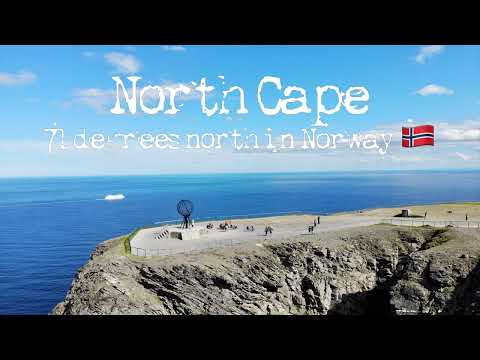
The steep cliff of the North Cape in Norway is located at 71°10′21″N 25°47′04″E, about 2,102.3 km (1,306.3 miles) from the North Pole. Nordkapp is often inaccurately referred to as the northernmost point of Europe. However, the neighbouring Knivskjellodden Cape actually extends 1,450 m (4,760 ft) further north. Furthermore, both of these points are situated on the island (Magerøya), albeit one connected by road to the mainland.
The North Cape, or Nordkapp in Norwegian, is the point where the Norwegian Sea, part of the Atlantic Ocean meets the Barents Sea, part of the Arctic Ocean. The midnight sun can be seen from 14 May to 31 July.
We went here to visit on a cruising journey with Hurtigruten from Bergen to Kirkenes. Our ship, M/S Kong Harald, arrived to the harbor in the fishing town Honningsvåg at 11.15 am, and we had around three hours stop to explore the island Mageröya. We took the bus to Nordkapp and it was a beautiful sight. Not many days in the year are with blue sky and sun. We were lucky! The same evening we experienced the midnight sun as there were very few clouds in the sky and the sun was breathtaking. The evening temperature the 15th of July was around 20 degrees Celsius.
I flew with the drone as the wind was not too strong. It was however enough wind to recognize the shaking of the drone when it was far out in the sea. Rain deers were running around the area and a lot of tourist tried to come close to them to take a good photo. The place is definitely worth a visit! Enjoy!
Commenting disabled.
Up Next
-
42:29

Honda CB500X: North Cape 2022 - DAY 4 (Tana - North Cape - Olderfjord)
-
07:01
North Cape Norway ???????? Driving to North Cape E69
-
56:03
FLYING OVER NORWAY (4K UHD) 1HR Ambient Drone Film + Music by Nature Relaxation™ for Stress Relief
-
19:30
Cruising Norway 3 - From Kiel to the North Cape with MSC Part 3 - Honningsvag and North Cape
-
09:52
SplitScreenDrive - Road to Nordkapp (North Cape) + some drone footage 07.09.2022
-
04:45
Skarsvåg, Trondheim, North Cape and Hammerfest in Norway 1970's old cine film 103
-
Shanty (seamans working song) from Statsraad Lehmkuhl in the Tall ships races in Stavanger
-
Geiranger - Live now